On the Severn

The United States Naval Academy at Annapolis, just a few meters off of Peregrinus's stern, as it lays this afternoon on a mooring buoy on the Severn river.

Annapolis, founded 1649, was known earlier as Anne Arundel Towne, after the wife of the 2nd Lord Baltimore, and daughter of Thomas Arundell, 1st Baron Arundell of Wardour, by King James, and Count (Reichsgraf) of the Holy Roman Empire, by Emperor Rudolf II.

image.jpg

Amel Rendezvous

A bunch of Amel sailors decided to meet up this weekend in Saint Michaels.  A variety of models are represented, from Amel Sharki to Amel Santorin to Super Maramu.    We had an impromptu party at Peregrinus from 11am to 5pm, and afterwards the crew of Brevis had us over for a gracious dinner.  

The town began as St. Michael's parish in 1677.  It is now a very picturesque village full of little family owned stores and popular in Maryland as a wedding and honeymoon destination.

A raft-up of three Amels.  Foreground, Aletes (with Mike waving), followed by Peregrinus and Fiasco. July 12.

A raft-up of three Amels.  Foreground, Aletes (with Mike waving), followed by Peregrinus and Fiasco. July 12.

Things you come across on a Tuesday morning on the Chesapeake

The Pride of Baltimore II, a topsail schooner built in 1988 by the state of Maryland, and then given away to a non-for profit.

That's the flag of Maryland on the foremast, the arms of the 2nd Baron Baltimore, founder and Propietary Owner of the colony.  The colony remained a Calvert possession until 1776; not coincidentally, the cliffs on the of the picture are the Calvert cliffs, now home to an LPG terminal and a nuclear power plant.

Click on the photo to see more.

Lancaster County

We left the Elizabeth on July the 2nd to go to a "hurricane hole", i.e., a place where Peregrinus would be protected from the approaching storm.  The Admiral had identified nice broad basin at the mouth of Bells Creek, upriver on the East Corrotoman, which is a tributary of the Rappahonnock; the nearly round haven, which has a diameter of 1/2 mile, proved to be ideal, and the approach from the mouth of the Rappahonnock extremely beautiful to boot.  We found remarkable the high proportion (over 30%?) of sailboats vs. powerboats docked in front of people's homes.

This morning we went for a hearthy Southern breakfast at Yankee Point Marina, a family-owned operation on the grounds of a property purchased in December 1664 by some of the earliest settlers of Lancaster County, Major Edward Dale and his wife Diana Skipwith.

A hawk (or is it a falcon?) taking off from its nest on Yankee Point, Myer Creek, Corrotoman River, 7:59am 5 July 2014.  The Corrotoman is home to the peregrine falcon.  Nearly every navigation marker in this river is home to a predator ne…

A hawk (or is it a falcon?) taking off from its nest on Yankee Point, Myer Creek, Corrotoman River, 7:59am 5 July 2014.  The Corrotoman is home to the peregrine falcon.  Nearly every navigation marker in this river is home to a predator nest such as this.  iPhone 4S.

In Portsmouth

Windmill Point was the final Virginia stronghold of the 4th Earl of Dunmore, the Royal Governor of Virginia, after he had to serially flee from Williamsburg and from Gosport, but the Revolutionary army drove him from the Point in May 1776. He returned to England in July 1776, where the King continued to pay his Virginia salary until 1783. Nice job if you can get it.

Later in 1776, the Revolutionaries built Fort Nelson at the Point, but lost it to the British May in 1779, who occupied it until 1781. Benedict Arnold worked out of British Fort Nelson for a while.

Windmill Point is now known as Hospital Point and it is home to the oldest continuously running hospital in the U.S. Navy. We’ve been anchored off of it, in the Portsmouth waterfront, for a week.

If you come to Portsmouth, the Naval Museum and the Path of History are the recommended highlights, and the Admiral enjoyed the Saturday morning farmer’s market.

The Alférez gazes out at the Elizabeth from the Portsmouth waterfront in a rare moment of quiet in the river.  Here we have seen go by countless barges, sloops, cutters, ketches, yawls, powerboats, the USS Ramage (505 feet), Larry Silverstein’s…

The Alférez gazes out at the Elizabeth from the Portsmouth waterfront in a rare moment of quiet in the river.  Here we have seen go by countless barges, sloops, cutters, ketches, yawls, powerboats, the USS Ramage (505 feet), Larry Silverstein’s Silver Shalis (174 feet), Michael Saylor’s Usher (154 feet), the Amel Maramu Bearaway, and many others.  June 24, iPhone 4S, ISO 50, 1/1493”

We got a kick out of the Airport password in a coffee shop in Portsmouth.

We got a kick out of the Airport password in a coffee shop in Portsmouth.

Isabella

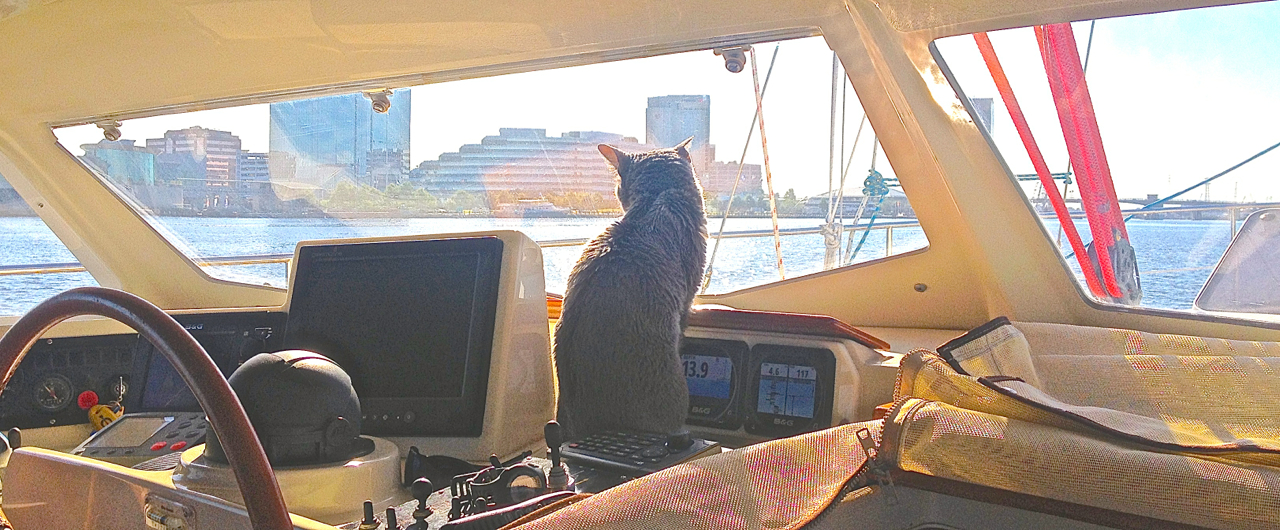
It is thought that the Chief Officer was born in Miami sometime in 1998.  She came to us skinny and with several illnesses, from an abusive home, when she was around two.  Her first year with us she mostly spent in hiding while we were around.  In her second year, she warmed up to the Admiral, and in the third, she stopped scurrying anytime the Seaman was home, and from the fourth year and onwards she became the most outgoing of our cats.  Isabella snuggled up visitors, and many have remarked that she was the dearest.

She was Philippe's best friend, and the Seaman used to say that all she wanted was to be loved, but in truth, her first love was food.  Oh, how she loved food.  She was fierce about her breakfast, lunch, dinner, and her snacks.  In her later years, when she went on a low protein diet for her progressive renal failure, she used to try and steal Philippe's and the Alferez's food, and skulk around their plates.  The Admiral let her cheat a bit, because Isabella's charms couldn't be resisted.

At first she used to get seasick while sailing Peregrinus, but as with the other challenges in her life, she overcame it.  Isabella was a fighter, but in the end, old age can't be beaten.  She went to sleep June 17, 2014, in Virginia Beach, aged 16.

Isabella as a 12-year old lady, taking the sun from her 36th floor window.  May 28, 2010, iPhone 3G. 

Isabella as a 12-year old lady, taking the sun from her 36th floor window.  May 28, 2010, iPhone 3G. 


The river in the sea

Merely following the Gulf Stream helped us move a lot of miles on our trip to the Chesapeake, particularly because winds were fickle that week.  We followed the Stream all the way to 35 degrees N, 75 degrees W.

Here is some of the information we used during the trip, with some plotting we did on top of it.

image.jpg


Night navigation in the 21st century

It took five nights to get from Palm Beach to Norfolk, and friends have asked whether we might have gotten lost or tired.   We were considerably aided by the devices shown below, on this picture taken on our first night.  From left to right, foreground row:

  • Raytheon autopilot keypad (green screen), partially shadowed by steering wheel. This redundant system was not used on this trip.
  • Magnetic compass.  The only analog instrument on this photo.
  • Keypad to control the B&G chartplotters above and below deck.
  • Bluetooth Simrad VHF extension.  This wireless handheld mic/speaker/screen duplicates the VHF radio installed below deck.

Background row:

  • B&G ZT7 chartplotter, showing a wind rose with our possible tacking angles and histograms of wind speed and direction for the last hour.
  • B&G Z12 chartplotter extension (dumbscreen duplicates the unit installed belowdecks) showing navigation chart, radar, and AIS targets on the left and traditional radar on the right.
  • Three B&G Tritons, showing from left to right: wind rose, histogram of GPS speed for the last 30 minutes, and target, actual, and rudder B&G autopilot performance indication.

The critical information could be shown in a fraction of these screens, but we are glad that Peregrinus' systems have room for redundancies.  We had one chartplotter reboot after four days of continuous use and we had a touchscreen go haywire once due to device overheat –the underlying device remained operational when accessed from an iPad.  We also had a depth sounder show 27 feet depth for a few minutes when we were 1200 feet above sea bottom.   These glitches sorted themselves out, but we were never relying solely on any one piece.

Peregrinus offshore on the Gulf stream, 10:05 pm 9 Jun 2014.  iPhone 4.

Peregrinus offshore on the Gulf stream, 10:05 pm 9 Jun 2014.  iPhone 4.

A $10 billion view

We woke up to this view from the aft deck of Peregrinus this morning: the airplane carriers USS Harry S Truman (CVN-75) and USS Theodore Roosevelt (CVN-71).  Not clear whether the $4.5 billion a piece price tag includes the 90 aircraft on board each; probably not.  

Also in the picture, an Euro-style carrier (helos and Harriers only), possibly USS Wasp.  But the helo/Harrier carriers are only $750 million and only carry 40 or so craft.

It would be very nice if, like the aircraft carriers, Peregrinus also had clean, emissions-free nuclear-powered engines on board: we would only have to fuel up every 20 years.

Westerly view from Peregrinus at Willoughby Bay, Norfolk.  iPhone 4S, ISO 50, 1/2,762", 15 June 2014

Westerly view from Peregrinus at Willoughby Bay, Norfolk.  iPhone 4S, ISO 50, 1/2,762", 15 June 2014